Campus Cycling Plan Implementation
The University of Victoria is making several changes to create a bicycle-friendly campus that is designed for people of All Ages and Abilities (AAA). The Campus Cycling Plan guides future campus cycling infrastructure, such as building more bike paths, places to park bikes, and spots where people can freshen up after riding. These changes are meant to make it safer and more comfortable for people who walk and bike around our campus.
If you’re curious to know more about the Campus Cycling Plan and how it was made, you can find more information on the Campus Cycling Plan webpage.
Key strategies
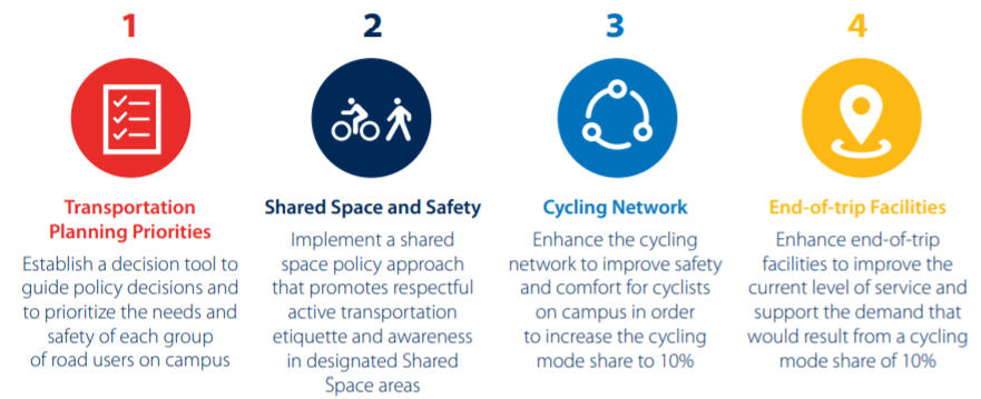
Over ten years, the Plan sets out how we will make biking and walking better on campus, based on four key strategies:
- Prioritizing active transportation planning: A Transportation Priorities Hierarchy was created to serve as a decision-making tool to help prioritize different ways of moving around campus – and balancing the needs and safety of pedestrians, cyclists, transit and private vehicles.
- Sharing space and being safe: Through education and awareness, speed management, and signage, signals and lighting, campus users are encouraged to treat each other well and be careful when moving around, especially inside the Ring Road area.
- Creating a better bike network: Improving our cycling network so that people feel safe and comfortable when they ride to and from the campus. It will connect different paths together and give spaces for people who walk, bike, skate, or even ride things like skateboards and scooters.
The goal is to make more people choose biking, where at least 10% of all people use bikes to move around.
- Bike parking, places to freshen up, and sharing bikes: Ensuring that new and existing buildings have amenities to make bike trips better. Where possible, buildings will be equipped with showers and change rooms, as well as sufficient bicycle parking.
Cycling network improvement areas
Developing an All Ages and Abilities (AAA) Cycling Network on campus will improve safety, enhance cycling facilities, enhance route connections and provide separated travel spaces for pedestrians, cyclists (as well as other human-powered modes such as skateboarding) and vehicles.
Seven locations were identified for pathway improvements by the campus community during the engagement phase of developing the Campus Cycling Plan.
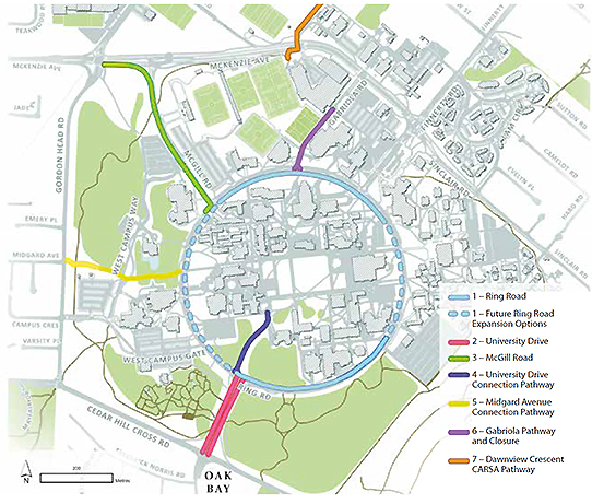
What's currently in progress:
Cycling network improvements taking place 2023-2026 will include:
- Ring Road Phase 1: University Drive to Bob Wright Building
The implementation of these improvements is funded in part by the Government of Canada through the Active Transportation Fund
Future/planned improvements
- Ring Road Network Improvement (McGill Road to SUB)
- University Drive Network Improvements
Recently completed cycling improvements
These represent important links in the AAA network that will promote connectivity and improved transitions across existing cycling infrastructure and facilities:
Dawnview Crescent-CARSA Pathway
- Separated cycling and pedestrian pathways
- Intersection crossing improvements
- Greenery & landscaping
Gabriola Road Pathway
- Separated cycling and pedestrian pathways
- Intersection crossing improvements
McGill Road Pathway Improvements
- Separated cycling and pedestrian pathways
- Intersection crossing improvements
- Bike racks/lockers and washrooms/changerooms
- Greenery, landscaping & upgraded lighting
University Drive Connection Pathway
- Separated cycling and pedestrian pathways
- Intersection crossing improvements
Midgard Avenue Connection Pathway
- Separated cycling and pedestrian pathways
- Intersection crossing improvements
- Greenery & landscaping