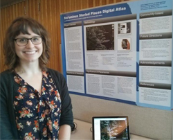
Elders' voices find home on Google Earth: the Stz'uminus Storied Places Digital Atlas
Long before settler culture attached the names of explorers, businessmen and political leaders to the mountains, rivers and landscape we now call Vancouver Island, the traditional names used by First Nations carried a wealth of information about those places—information that anthropology student Amy Becker has been working to preserve.
fair.
Becker, recipient of a 2013-14 Jamie Cassels Undergrad Research Award (JCURA), explains “Indigenous place names are embedded in the culture, landscape, language and identities of the people who use them.”A place name may contain information about environmental conditions, cultural knowledge and heritage, as well as historical information.
Becker discovered her passion for research and community-based projects while taking an ethnographic mapping course taught by Dr. Brian Thom (anthropology). “It was my first introduction to Indigenous place names, mapping, and traditional use studies,” says Becker. “Thom also showed us how to use Google Earth and how to incorporate multi-media into a map.”
It was a natural next step for Becker to apply what she learned in class to a grassroots, community collaboration between the Stz’umnius First Nation and Project Reel life, a Ladysmith-based community program that works with youth. Becker’s goal was to introduce a focus on place names to the existing collaboration and make a digital atlas of about 20 Hul’q’umi’num’ language place names in Ladysmith using videos of elders’ stories.
“The goal of the project was to embed videos of elders’ place-based stories into a digital map so community members can continue to listen to the names and stories through computers, laptops and mobile devices,” says Becker.
The Stz’uminus Storied Places Digital Atlas project is a great example of what can be gained through community-based collaboration, bringing elders, youth, and university students and researchers together. For Stz’uminus youth, meetings with elders are a rich experience. “The youth really enjoy recording and listening to elders’ stories about place names,” says Becker. “I think they view their elders as stars in their community.”
“By making the Stz’uminus Storied Places Digital Atlas available for viewing on a smartphone platform, this project acknowledges the need for up-to-date technologies to address community needs,” Becker adds, “especially at a time when youth are becoming increasingly engaged with their phones.”
Becker will be holding a Google Earth mapping workshop for Stz’uminus youth in May so they can learn hands-on the mapping technique used by researchers. Becker hopes the research can continue with further funding to answer such questions as, “in what ways is a digital map effective and ineffective as a tool for mobilizing traditional knowledge within the Stz’uminus community?”
As she looks ahead to graduation this June, Becker feels a renewed confidence in her research skills and is pleased with her experience in the digital mapping project. She credits her minor in professional writing for giving her practical hands-on skills in editing and web design, and reflects that her co-op terms were also valuable, adding real-life work experience to the mix. And wherever life takes her next, her JCURA research project with the Stz’uminus community means that Becker will continue to listen for the names of the places she goes.